
BuzzCycles urge planners to prioritise walking and cycling in new Lidl supermarket development
Lidl’s Leighton Buzzard Application: What You Need to Know
Lidl has submitted a planning application to Central Bedfordshire Council for a new store located off Billington Road, in the Spinney Park Industrial Estate, Leighton Buzzard. The site is situated between the Harmill Industrial Estate and a new residential area. This development promises to enhance local shopping options, offer affordable groceries, and create new employment opportunities. The application details the plans for a sustainable and accessible supermarket designed to serve the needs of the growing Leighton Buzzard community.
The full details of the planning application can be found at CB/25/00576/, to comment on the planning application follow the consultation tab.
Walking and Cycling Neglected: BuzzCycles’ Analysis
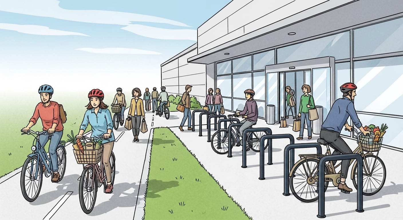
We agree that the development’s location is sustainable, enhances shopping options in the local area, and has the potential to reduce the length of car journeys for shopping. Regarding cycling facilities, Lidl is providing 12 customer bike parking spaces underneath the canopy and in front of the store’s glazed end. Additionally, secure bike parking is available for employees within the warehouse.
Our objections to this planning application are centred around its failure to prioritise and adequately provide for walking and cycling access, despite policy requirements. Key concerns include:
- Inconsistencies and Omissions in Documentation: There are contradictions between the Transport Assessment and the Design & Access Statement. For example, a zebra crossing mentioned in the Transport Assessment is not shown in any diagrams.
- Lack of Priority for Active Travel: The design does not prioritise walking and cycling over vehicle movements. Statements claiming priority is given to pedestrians and cyclists are not reflected in the plans.
- Inadequate Infrastructure: Proposed footways are too narrow for shared use paths, particularly on key routes like Billington Road. Crucial infrastructure like protected crossings and dropped kerbs are missing or vaguely planned.
- Unsafe Junction Design: The design of the Billington Road junction and other access points creates potential conflicts and safety issues for pedestrians and cyclists.
- Insufficient Detail and Ambiguous Commitments: Important elements like pedestrian crossings are not detailed, and commitments to improvements are weak (e.g., using “may” instead of “will”).
- In essence, while we acknowledge the benefits of the development, we strongly object to the application in its current form due to its inadequate and unsafe provisions for walking and cycling, its lack of accessibility for disabled users and conflict with local and national policy.
Strength in Numbers: Why Objections Matter
The number of people objecting to a UK planning application matters because it gauges public concern and the proposal’s potential impact on the community. In cases where the application fails to demonstrate sufficient cycling and walking access, many objections can emphasise the strength of local feeling regarding the inadequacy of sustainable transport provisions. This collective opposition can pressure the local planning authority to scrutinise the application more rigorously, which can then require the developer to make significant amendments to improve walking and cycling access.
Please comment/object here CB/25/00576/, It only takes 2 minutes; it just needs a sentence or two, a few ideas are below:
- I object to this planning application because it prioritises vehicular access over the safety of pedestrians and cyclists, directly contradicting local and national policies that mandate the prioritisation of active travel. The proposed junction design, particularly at Billington Road, poses significant safety risks due to insufficient crossing provisions and inadequate infrastructure for vulnerable road users.
- This application fails to provide adequate and safe access for pedestrians and cyclists, demonstrating a clear disregard for inclusivity and sustainable transport. The lack of protected crossings, dropped kerbs, and sufficiently wide shared paths, particularly along key routes like Billington Road, creates barriers for disabled users and discourages active travel, undermining the community’s needs.
- The proposed development prioritises vehicular access over walking and cycling, resulting in a design that is unsafe, unsustainable, and contrary to policy.
BuzzCycles Response In Full
Leighton Buzzcycles are writing to OBJECT to this planning application, with reference to the CBC Travel Plans & Transport Assessments policy document which states that “Travel Plans are critical to ensure use of sustainable modes is maximised and promoted”, and with reference to Government guidelines (NPPF/PPG/LTN120) which state that “walking and cycling infrastructure must allow walking/cycling movements to take priority over vehicle movements”. The design of the Billington Road junction in particular does not meet these requirements, and the whole plan in general does not meet these requirements.
The application’s Travel Plan section 1.5 states that “[the] emphasis [is] on employees as it is difficult to influence the general public”. This is a ludicrous statement from SCP since it effectively acknowledges they are going to ignore CBC’s requirement to encourage customers’ walking/cycling journeys because it is “too difficult”.
The road junction with Billington Road is designed entirely with vehicle movements in mind, as the diagram on page 99 of the Transport Assessment Appendix Vol 2 shows. The path along the west side of Billington Road simply turns into the LIDL site with little consideration for journeys continuing past it along Billington Road. The path is only specified as 2m wide but should be 3m wide. The actual crossing over the entrance road has no protected surface and the “island” is far too small to allow a walking/cycling crossing movement to take place in two stages. This makes it very difficult for a ‘through’ cycling journey along the Billington Road shared path. It is critical that cycle journeys between Theedway and Chartmoor Road are not impeded by this junction design. The Design & Access Statement page 8 states that this route is “a key route within the area” therefore walking/cycling must not be impeded.
The lack of a protected crossing also makes it difficult for walking customers from the Theedway area to cross to the north side of the access road to reach the shop, compounded by the fact that there is no protected crossing further into the site either. All this is entirely offputting for walking/cycling customers.
The Design & Access Statement page 5 states that the design “will need to take account of… improving access for both vehicles, cyclists and pedestrians from local roads”. Placing “vehicles” first shows immediate bias for that transport mode. As we will see, the design does not go far enough to improve walking/cycling access.
The Design & Access Statement page 12 mentions proximity to existing cycle routes but does not explain how users of these routes access the LIDL shop. Unsurprisingly, these details are specified for car users.
The Design & Access Statement page 14 states that “pedestrian access is proposed directly from Chartmoor Road”. This statement must be changed to mention cyclist access as well, since there is a 3m shared-use path along the south side of Chartmoor Road. Also, none of the diagrams show any access onto Chartmoor Road, so they must be updated to show where this will be.
The Design & Access Statement page 14 shows another “existing land” access road joining the south side of the LIDL access road immediately next to Billington Road. It is not clear how walkers/cyclists negotiate this whole area safely given the complexity of the roads – there is no protected crossing for either the main access road or the “existing land” access road.
The Design & Access statement page 14 does not show “connections to existing cycle routes”. It also does not show, as stated earlier, how cyclists on the shared-use path will cross the mouth of the junction, which will have intense use by vehicles – this situation is made worse by the close proximity of other access points on the west side of Billington Road a few metres south.
The Design & Access Statement page 16 shows a couple attempting to cross the very busy Billington Road. We do not envy them as the photo does not show a protected crossing or a dropped kerb on the other side of the road – discriminatory against wheelchair and pram users and cyclists.
The Design & Access Statement page 17 shows a couple attempting to cross the busy LIDL car park entrance junction Road, which has one entrance and TWO exit lanes with no central refuge and is therefore very wide indeed. We would argue that it is indeed impossible to cross on foot due to its width. The photo shows no protected crossing or dropped kerb on either side of the road – hence presumably why they look like they are about run across in fear of their safety.
The Design & Access statement page 22 mentions cycle stands with space for 12 cycles, but this is a SHOP so people are more likely to be using trailers, box bikes, cargo bikes etc which obviously take up more space than a simple cycle. We would also request that provision is made for charging E-Bikes.
Page 22 shows a very poor design indeed for walking/cycling. It does not show cycle access at all! It shows pedestrian access along the north side of the entrance road and north along Billington Road, but no access to/from the south. It does not show how pedestrians cross to/from the shop to/from the south side of the access road. It does not show how walkers/cyclists safely cross the other “existing land” access road to the south of the main junction. It shows the (shared?) path on the south side of the access road curving south along Billington Road but then petering out to nothing – preventing continued use to the Theedway area. It does not show protected crossing of the main access road at its entrance, and the central island is too small and dangerous.
The Design & Access Statement page 24 shows a gentleman with a walking stick attempting to cross the access road. How is he supposed to cross a busy two-lane road at this point with no zebra crossing!
The Travel Plan section 1.5, as mentioned earlier, states that the emphasis will be on employee cycle parking. We note that there will be space for 130 customer car parking spaces. Given that customers will most likely be coming from the Theedway and Sandhills areas, which are all within 5 minute walking distance, we feel this is considerable overprovision.
The Travel Plan page 18 mentions a footpath running along the south side of the site to Fortuna Mead. Currently this path is very overgrown and partially blocked so cannot, as it stands, be put forward as a way to access the new shop site unless it is cleared as part of the “net gain” of the development.
The Travel Plan page 20 section 4.13 glosses over how a cyclist would actually access the site. It simply states that Chartmoor Road has “on road cycle lanes” but does not mention the 3m shared use path on the south side which is critical for cyclists to access the new shop. It also does not mention how a cyclist would safely access the site from the Sandhills area, or from Theedway travelling north along Billington Road (as mentioned elsewhere, the shared path south of the new site is shown petering out along the west side of Billington Road).
The Travel Plan page 22 section 4.23 blithely states that “access to the site by cycle is good” when this is plainly not the case, as above.
The Travel Plan page 24 section 5 specifies that the Store Manager will be the TPC but does not specify how sustainable travel will be promoted to local residents (leaflets, meetings, maps, incentives, journey planning etc). We remain sceptical that “yearly monitoring and repeat survey” will take place given that CBC have no staff capacity to monitor that the Store Manager TPC carries out the Travel Plan tasks.
Whilst a lot of work has obviously gone into the Transport Assessment, we have some issues with it.
The Transport Assessment page 3 states “LIDL have designed the site layout to be attractive to pedestrians and cyclists”. As cyclists, for all the reasons given earlier we would not wholeheartedly agree with that.
The Transport Assessment page 8 states “the approach routes have been designed to be attractive and easy to use for all vulnerable road users”. Again, we would beg to differ for aforementioned reasons.
Earlier documents having shown that there is no safe way to for walkers/cyclists to cross the entrance road, we note that the Transport Assessment page 24 section 5.4 states that there will in fact be a “zebra crossing to the west of the main vehicular access”. However this is not shown on any of the diagrams or mentioned anywhere else in the documents. Section 5.4 mentions dropped kerbs and tactile paving but only within the car park.
The Transport Assessment page 26 section 6.1 states that “priority has been afforded to pedestrian and cycle movements”. This is not the case.
The Transport Assessment page 26 section 6.1 states that the bellmouth entrance will be provided with “minimum 2m footways”. This implies cyclists will be expected to use the main carriageway and not a segregated 3m shared use path, and given the complexity of this area we do not think this is a reasonable or satisfactory provision for cyclists.
The Transport Assessment page 26 section 6.1 states that “footway connections into the LIDL site and up to the store entrance via defined segregated routes with zebra crossings of the car park aisle(?)” and “additional enhancements of the pedestrian routes across each bellmouth MAY be considered at detail design stage”. These pedestrian crossings are not shown on any diagram or mentioned in the Design & Access Statement. “MAY” is not a firm enough commitment, the word ought to be “WILL”.
The Transport Assessment page 26 section 6.1 states that “improvements to the section of Billington Road along the site frontage will incorporate footway widening to a minimum of 2m”. This “footway” is actually a shared walking/cycling path as defined in the CBC Local Cycling And Walking Plan for Leighton-Linslade (LCWIP)and as such must be 3m wide along its whole length. Billington Road is a key walking/cycling access route in/out of the town centre so a 3m shared path is an essential feature.
The Transport Assessment page 26 section 6.1 states that “pedestrian crossing points at the
Chartmoor Road/Billington Road roundabout junction will be improved for dropped kerbs and tactile paving”. This is not mentioned in the Design & Access Statement, or shown on any diagrams or photographs.
In summary, whilst we agree that the location for the development is “sustainable” and improves shopping choice in that local area and potentially reduces the length of shopping car journeys, we OBJECT to the application because it does not prioritise walking/cycling over vehicle use, does not promote walking/cycling over vehicle use, does not address the needs of disabilities (no protected crossings or dropped kerbs), and rather than minimising the scope for dangerous conflicts between pedestrians/cyclists/vehicles it actively facilitates those dangerous conflicts.

Leave a Reply